
It’s been a tough year for Big Sur. The Dolan Fire burned almost 125,000 acres of the region between August and December 2020. After that it rained, and the rainfall on fresh fire scars was feared to cause mudslides, and it did. On Thurs. Jan. 28, 2020, a debris flow crossed Highway 1 and collapsed a section of the road into the ocean. Efforts to repair the highway have been underway since February, and the road is scheduled to be back in service by the end of April. Tourists have had to avoid most of the hiking trails, and since February, it has been impossible to make the famed Highway 1 drive along the coast from Morro Bay to the Golden Gate.
With months of firefighting, precarious weather and road conditions as background, we took our time exploring this area. Initially we jumped from one place to another, looking for beaches, visiting Garrapata and Pfeiffer beaches. Pfeiffer Beach is a particularly beautiful spot. Rocks just offshore have a natural opening. The tide billows through, and at certain times, the sun sets right through this natural window. We met photographers setting up to catch views of the sunset on a calm afternoon. (The wind makes a big difference, as the second time we visited the wind was so strong we had to hide in the lee of the rocks, then leave.)
Once we realized that Big Sur is all about the views of the rocky coast, and has few beaches to walk on, we began working our way south from Carmel along Highway 1, stopping at the overlooks and taking any available walking trail along the the cliffs. Soberanes Point has a particularly nice series of trails along the rocks.
Weather and Covid have conspired to close some important stops in Big Sur. The Point Sur Lighthouse is a beautiful area, but has been closed for months. I just read that it is reopening for docent-guided tours. It sounds like there will be no wandering along the shore on one’s own.

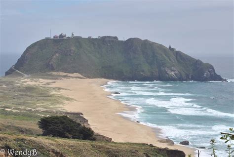
There is a beautiful beach lying just north of the Point Sur lighthouse that I was looking forward to visiting when the grounds opened again, but I found that it is permanently closed to the public. This comes as a bit of a shock in California, where the right of pedestrians to walk on any beach up to the high tide mark is a law that has withstood years of attack by the rich (look up David Geffen and the California Coastal Commission…). About 15 miles of coastline, including this beach are fenced off and posted by the El Sur Ranch. Jonathan read up on it and the owner is seen as a great benefactor of the region, honorary member of the fire department, generous to local causes. I remain puzzled by why the ranch is allowed to keep long sections of coast land private in the face of laws to the contrary. The property goes back to a land grant in the mid-19th century, and I’m sure there are reasons, even if I don’t particularly like missing out on this stretch of the coast.
When I become discouraged that sections of the coast are not available to visit, I have to keep in mind that we have had great success in visiting most of the coast that can be reached on foot without overnight camping. One of our favorites is the Carmel River State Park, right down the road, open most of the time, a perfect place.


Have you been to Pfeiffer Beach?!
LikeLiked by 1 person
That was the first place we visited, back in November. Now it’s just about the last stop. The place where the road fell in is just four miles farther down.
LikeLiked by 1 person